The Boxgrove Wider Area Project: Mapping the early Middle Pleistocene deposits of the Slindon Formation across the coastal plain of West Sussex and eastern Hampshire.
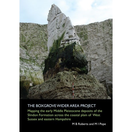
The Boxgrove site is one of the most important localities in the world for studying the archaeology, geology and palaeoenvironments of the Lower Palaeolithic, during the early Middle Pleistocene. The Boxgrove Wider Area Project recorded the surviving marine and terrestrial sediments of the Slindon Formation, which contain the Palaeolithic in situ landsurfaces, over an east-west distance of 26km between Westbourne and Arundel, 15.5km of which has the potential to preserve archaeological material in a sedimentary sequence similar to that at the Boxgrove site.
Detailed Description
The Boxgrove site is now considered to be one of the most important localities in the world for studying the archaeology, geology and palaeoenvironments of the Lower Palaeolithic, during the early Middle Pleistocene. However, prior to the Raised Beach Mapping Project and results presented in this volume, the surviving disposition of the marine and terrestrial sediments of the Slindon Formation, which contain the Palaeolithic in situ landsurfaces, was unknown. Although sediments identical to those at Boxgrove had been recorded over a distance of 7km between the Valdoe Quarry and Penfold’s Pit at Slindon, the wider distribution of the formation needed to be ascertained and mapped.
When completed, the project had mapped the complete distribution, in the form of outcrops and sub-crops, of the Slindon Formation over an east-west distance of 26km between Westbourne and Arundel, 15.5km of which has the potential to preserve archaeological material in a sedimentary sequence similar to that at the Boxgrove site. The results from the Raised Beach Mapping Project demonstrate conclusively that the sediments of the Slindon Formation formed in a semi-enclosed marine bay formed by two arms of downland situated, on what is now the Coastal Plain, to the south of the current South Downs.
For all queries in regards to this product please contact :-
louise.rayner@ucl.ac.uk
PLEASE NOTE THIS ITEM WILL ONLY BE SHIPPED WITHIN THE UK, IF YOU ARE FROM OVERSEAS AND WOULD LIKE TO PURCHASE THIS BOOK PLEASE EMAIL THE FOLLOWING CONTACT DETAILS :-
louise.rayner@ucl.ac.uk